Meeting – ‘Archaeological Survey in the Wyre Forest: an Ancient Landscape Revealed’ – Tuesday 1st December 2015
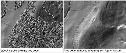
November 9th, 2015Our next meeting is on Tuesday 1st December when we will have a presentation by Adam Mindykowski, from the Worcestershire Archive & Archaeology Service entitled ‘Archaeological Survey in the Wyre Forest: an Ancient Landscape Revealed’. He will show how modern technology of LiDAR has revealed both Iron Age and Industrial Revolution sites which until recently have been invisible to the eye. Visitors are most welcome at all our events – see Home Page for details and contacts.
 Commences 8pm at St Saviour’s Church Hall, DY9 0NS. Visitors £2, including refreshments. Annual membership £10
WYRE FOREST (Another Point of View)
“Wyre”, it is suggested comes from Weogoran the name of an Anglo-Saxon tribe. It is also linked to Worcester as a source for the name.
Forest indicates an area reserved for hunting by the King and therefore subject to Forest Law. Areas for hunting by lesser mortals were either a chase or a park.
The Mortimers were Marcher Lords governing the southern third of the Welsh border. The line came down through Anne Mortimer, who married the Earl of Cambridge. Their son was Richard Duke of York and earl of March and his son Edward took the throne in 1461 as Edward IV. After that it is reasonable to suggest that the name “Wyre Forest” was used in documents.
The early boundaries are unknown but some suggest that they ran on the west bank of the Severn from Worcester to Bridgnorth and west to Cleobury Mortimer. The modern Wyre Forest is only 6,509 acres or 10 square miles.
The use of the area changed from hunting to one of supplying charcoal to the iron industry of the west midlands. Later small-scale coal mining was developed.
Waterpower was harnessed initially to provide power for blast furnaces but later on the traditional use of water for corn grinding occurred.
HHFS Research Group